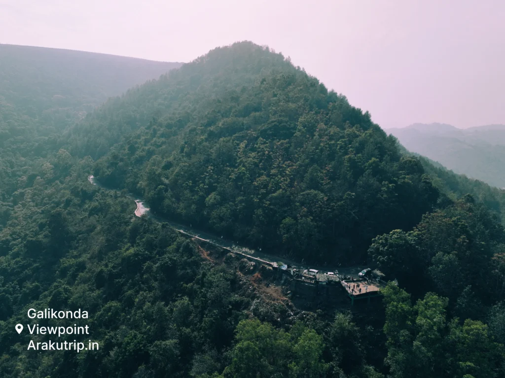
At the highest accessible elevation in the Visakhapatnam district, Galikonda View Point offers perspectives that transform how visitors understand the Eastern Ghats landscape. Standing at approximately 4,320 feet above sea level, this vantage point delivers panoramic views across valleys, ridges, and the serpentine railway line that connects Visakhapatnam to Araku Valley. For travelers seeking that defining photograph or simply a moment of awe at nature’s scale, Galikonda consistently delivers.
The viewpoint sits within the broader Araku Valley tourism circuit but occupies a category of its own. Unlike attractions with historical narratives or cultural exhibits, Galikonda’s appeal rests purely on what the eyes can absorb and the camera can capture. The experience varies with weather conditions, time of day, and seasonal factors, making repeat visits rewarding for those who return to Araku across different periods.
Experience the Panoramic Vistas of the Eastern Ghats
The Eastern Ghats run along much of peninsular India’s eastern edge, but few locations provide the comprehensive views available at Galikonda. From this elevation, the terrain unfolds in every direction with depth perception that two-dimensional photographs struggle to convey. Ridge lines recede into the distance, their profiles stacked behind one another in increasingly faded shades of blue and gray.
Valley floors visible below reveal the patchwork of coffee plantations, forest reserves, and occasional clearings where tribal settlements cluster. The agricultural patterns created by different crop types and land uses form geometric abstracts when viewed from sufficient height. During morning hours, mist often fills lower elevations while Galikonda remains above the cloud line, creating the famous “sea of clouds” effect that attracts photographers and nature enthusiasts.
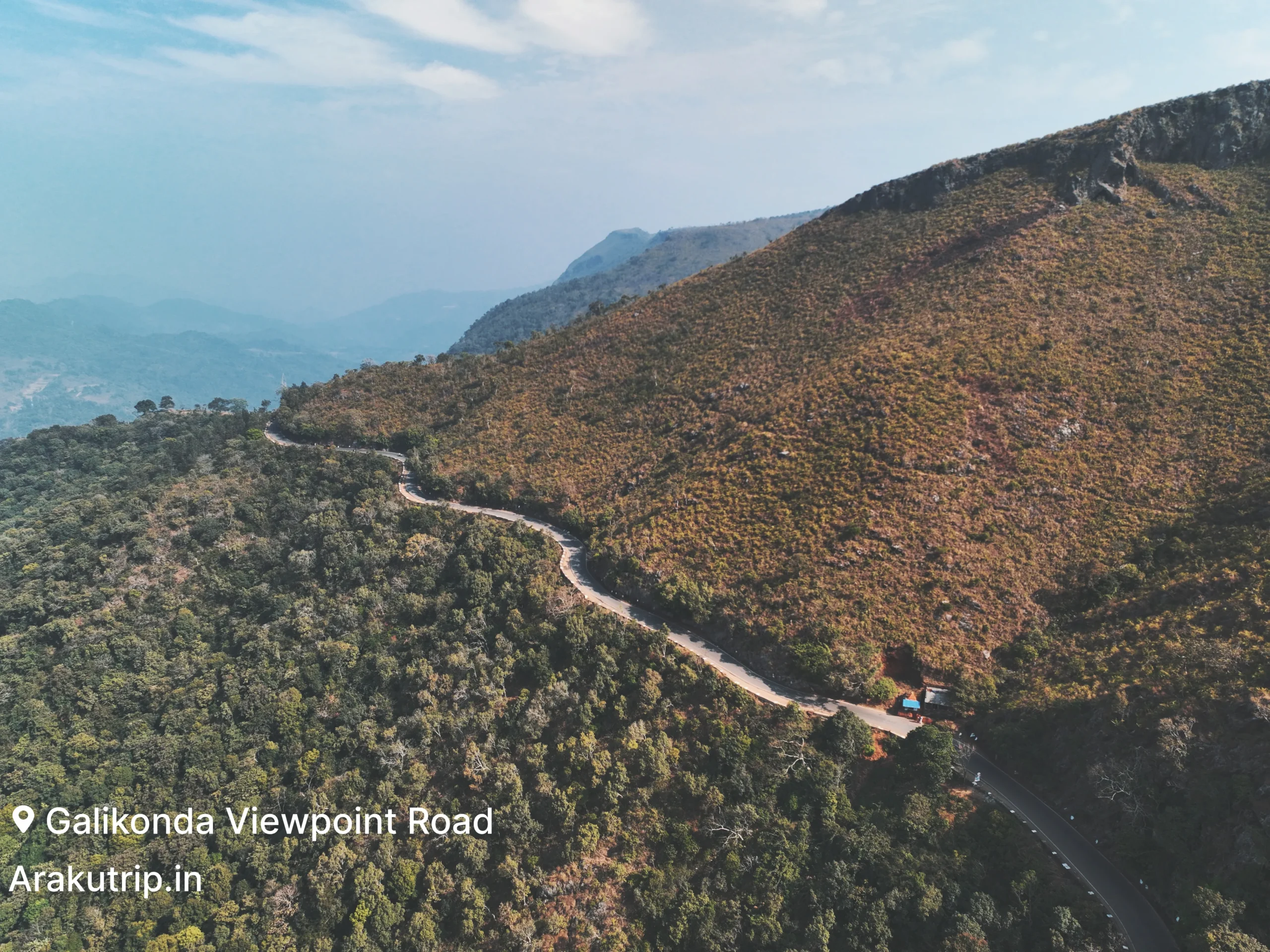
The Araku Valley railway line, an engineering achievement that crosses 58 tunnels between Visakhapatnam and Araku, becomes visible from Galikonda as a thin ribbon threading through the landscape. On fortunate timing, visitors witness trains emerging from tunnels, providing scale reference that emphasizes the vastness of the surrounding terrain. The railway bridges spanning valleys appear as delicate structures from this distance, their engineering significance apparent when viewed in context of the rugged topography they traverse.
Weather systems moving across the region create dynamic visual displays. Cloud formations build, shift, and dissolve over the course of hours. Rain curtains sometimes appear in distant valleys while Galikonda remains dry, allowing observation of weather patterns from an unusual perspective. These atmospheric conditions vary unpredictably, meaning each visit offers potential for unique experiences unavailable on other days.
Photography Tips: Capturing the Valley and Railway Tracks
Galikonda ranks among the premier photography locations in the Araku region, but capturing the views effectively requires attention to conditions and techniques that maximize image quality.
Lens selection significantly impacts results. Wide-angle lenses capture the sweeping panoramas but may produce images where distant features appear small and underwhelming. Telephoto lenses allow isolation of specific elements like railway bridges or mountain ridges but sacrifice the sense of vast scale. Many photographers find carrying both focal lengths provides optimal flexibility. Smartphones with multiple lens options offer convenient alternatives for casual visitors.
Golden hour lighting during early morning and late afternoon creates the most flattering illumination for landscape photography. The low sun angle adds dimension through shadows and brings warmth to the color palette. Midday lighting tends toward harsh and flat, washing out atmospheric haze and reducing the layered depth that makes Galikonda views compelling.
Mist and fog, while potentially obscuring views, create opportunities for distinctive images when present at appropriate densities. Partial cloud cover adds interest to skies that might otherwise appear uniformly blue. Completely clear days, while maximizing visibility, sometimes produce images lacking atmospheric drama. The most memorable photographs often capture weather conditions that add mood to the technical achievement of a sharp, well-exposed frame.
Tripod use improves results for serious photographers but faces practical limitations including carrying weight up the access path and stability on uneven ground at the viewpoint. Steady handheld technique with image stabilization suffices for most purposes. Focus stacking and exposure bracketing techniques help advanced photographers overcome the dynamic range challenges presented by bright skies and shadowed valleys.
Best Time to Visit for Foggy Mornings
Timing your Galikonda visit dramatically affects what you experience. The viewpoint remains accessible throughout daylight hours, but the character of views shifts substantially based on when you arrive.
The prime window for the famous misty conditions spans approximately 6:00 AM to 8:30 AM during winter months from November through January. During this period, temperature inversions trap moisture in lower elevations while higher points like Galikonda remain above the fog layer. The resulting sea of clouds effect, where valley floors disappear beneath white blankets while ridge tops emerge like islands, creates the images most associated with this viewpoint.
Arriving before sunrise requires early departure from Araku town, approximately 20-30 minutes by vehicle depending on road conditions and your accommodation location. The pre-dawn drive in darkness adds logistical challenge but positions you for the full progression from night to twilight to full daylight, potentially the most dramatic period for photography.
Summer months from March through May see fewer misty mornings due to higher overnight temperatures that prevent the condensation necessary for fog formation. Visits during these months may provide clearer long-distance views but lack the atmospheric drama of winter conditions. Monsoon months bring unpredictable cloud cover that may completely obscure views or create dramatic partial effects depending on weather patterns that day.
Distance from Araku Town and Road Connectivity
Galikonda View Point lies approximately 15 kilometers from Araku town center via roads that climb steadily from the valley floor to the elevated viewpoint. The driving route follows paved roads for most of the distance, though surface quality varies with maintenance cycles. Steep sections and tight curves characterize the final approach, requiring attentive driving but remaining passable for standard vehicles in dry conditions.
Travel time from Araku town typically spans 25-35 minutes depending on vehicle speed, traffic conditions, and the number of photo stops taken along the way. The road itself offers intermediate viewpoints where some visitors pause before reaching the primary destination. Returning via the same route takes similar time, with total round trip mileage around 30 kilometers.
Transportation options include private cab hire from Araku, personal vehicles for self-driving visitors, and occasional shared jeep services during peak tourist season. Cab drivers familiar with the route can be arranged through accommodations or at the Araku bus stand, with round trip costs typically ranging from ₹600-1000 including waiting time at the viewpoint.
No public bus service connects Araku town directly to Galikonda, making some form of private transportation necessary. Walking or cycling to the viewpoint is theoretically possible for extremely fit individuals but impractical for most visitors given the distance and elevation gain involved.
The viewpoint itself has basic facilities including a small parking area, tea and snack stalls operated by local vendors, and viewing platforms with safety railings at the most popular photography spots. Toilet facilities may or may not be available depending on maintenance status. Carrying water and snacks from Araku provides backup if vendor stalls are not operating during your visit.
Galikonda View Point rewards visitors who make the effort to arrive at optimal times with experiences unavailable at lower elevations. Whether your priority is photography, quiet contemplation of natural beauty, or simply adding a memorable highlight to your Araku itinerary, this elevated vantage point delivers perspectives that justify the early morning alarm and winding road journey.
Where is Galikonda View Point located in Araku Valley?
Galikonda View Point is located on the route between Visakhapatnam and Araku Valley. It is one of the highest viewpoints in the Eastern Ghats and offers panoramic views of valleys, hills, and coffee plantations.
Why is Galikonda View Point famous?
Galikonda View Point is famous for its breathtaking scenic views, mist-covered hills, and cool climate. It is considered one of the best photo stops during a Vizag to Araku trip, especially for sunrise and early morning views.
What is the best time to visit Galikonda View Point?
The best time to visit is early morning or late afternoon when the weather is pleasant and the views are clearer. Winter months (October to February) offer the most comfortable experience with misty landscapes.
Is Galikonda View Point included in Araku tour packages?
Yes, Galikonda View Point is usually included as a scenic stop in most Araku tour packages. It is covered during the journey from Vizag to Araku, allowing travelers to enjoy the views without any separate planning.
Is there any entry fee or facilities at Galikonda View Point?
There is no major entry fee to visit Galikonda View Point. Basic roadside facilities like parking and small tea stalls may be available, but it is mainly a natural viewpoint rather than a developed tourist spot.