The Majestic Duduma Waterfalls (175m) & Rani Duduma: The Complete Odisha Guide
The Majestic Duduma Waterfalls (175m) & Rani Duduma: The Complete Odisha Guide
Introduction: The Mist of Machkund
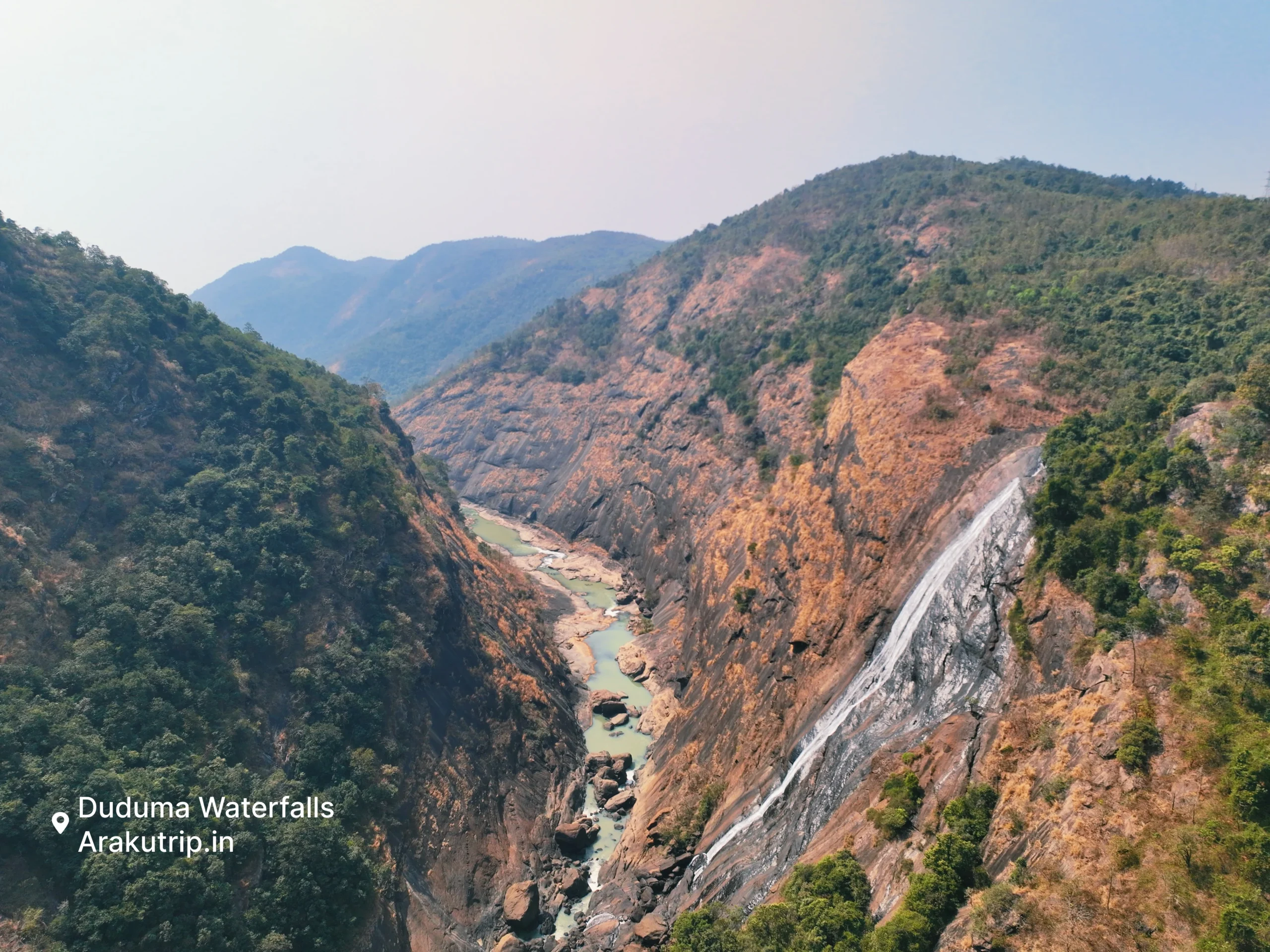
You hear Duduma Waterfalls before you see it. The sound builds as you approach—a deep, continuous roar that tells you something massive waits beyond the forest. Then you reach the viewpoint, and the gorge opens below: 175 meters of water dropping through mist into a chasm that swallows the river and releases it as electricity.
This is one of India’s highest waterfalls, also known as Matsya Tirtha in religious contexts. The Machkund waterfall creates a spectacle that photographs capture poorly—the scale, the sound, the constant spray rising from depths you can barely see require presence to understand.
We first visited as teenagers, part of a trip that took us beyond Araku into Odisha territory. The falls were running at near-peak flow, monsoon-fed and furious. We stood at the railing, spray coating our faces, trying to comprehend how much water was moving through this single point. Nothing in our valley compared.
Duduma jalprapat isn’t just scenery—it’s infrastructure. The falls feed the Machkund Hydroelectric Project, a collaboration between Andhra Pradesh and Odisha that has generated power since the 1950s. The same water that creates the spectacle also turns turbines, supplying electricity across two states.
For nature lovers seeking Koraput waterfalls worth the journey, Duduma delivers something raw, loud, and genuinely impressive.
Geography: River, District & State
Understanding Duduma’s geography matters because the waterfall sits on a boundary.
Duduma waterfall in which river? The Machkund River, also spelled Machhkund. This river originates in the highlands of Odisha and Chhattisgarh, dropping suddenly at Duduma before continuing into the reservoir that powers the hydroelectric project.
Duduma waterfall in which district? The falls mark the boundary between Alluri Sitharama Raju district (Andhra Pradesh) and Koraput district (Odisha). The waterfall belongs to both and neither.
Tourism Access: Most visitors approach from the Odisha side through Onukudelli. The Duduma waterfall Koraput route provides established viewpoints and visitor facilities. The Duduma waterfall Odisha designation appears in most tourism materials because Odisha has invested more in visitor infrastructure.
The Machkund Duduma combination represents something genuinely shared—a natural wonder serving both states with water collected from Odisha hills, generating power for Andhra and Odisha alike.
Important: Duduma vs. Rani Duduma (Don’t Get Confused!)
Two waterfalls share similar names. Confusing them leads to disappointed expectations.
Duduma Waterfalls (The Big One):
The 175-meter giant near Onukudelli, on the AP-Odisha border. You view Duduma from railed viewpoints above the gorge—you cannot safely descend to its base. The combination of slippery rocks, powerful currents, and hydroelectric operations makes bathing dangerous and prohibited.
Duduma is a spectacle to witness, not a place to swim.
Rani Duduma Waterfalls (The Picnic Spot):
Located approximately 35-40 km away near Nandapur (closer to Koraput), Rani Duduma waterfalls offers an entirely different experience. “Rani” means Queen. This smaller, multi-tiered cascade drops in stages, with pools safe for bathing. Families visit for picnics and wading.
Which Should You Visit?
Massive view and overwhelming sound? Go to Duduma. Swimming, picnics, family wading? Go to Rani Duduma waterfalls. If you have time, visit both—different experiences serving different purposes.
Sightseeing & Tribal Culture
Duduma offers more than the waterfall itself.
The Viewpoint:
A railed observation platform provides the primary viewing position. From here, you look down into the gorge, mist rising to meet your gaze. Duduma waterfalls photos capture something unusual—the mist creates atmospheric effects varying by hour and season. Morning light through mist, rainbow fragments when angles align.
Onukudelli Market:
The Thursday Market at Onukudelli brings the Bonda tribes to trade—one of India’s most distinctive indigenous communities, maintaining traditions that set them apart visibly. The Bondas are among India’s oldest and most isolated tribal groups.
Important: Photography of tribal people is restricted and ethically complicated. Approach with respect rather than cameras. The market serves the community’s economic needs, not visitor curiosity.
Distance & How to Reach
Duduma’s remote location—on a state border, in tribal territory—requires planning.
From Araku Valley:
The Duduma waterfalls distance from Araku is approximately 70 to 80 km, requiring 2.5 to 3 hours driving through scenic ghat sections.
From Vizag:
Approximately 165 km direct. Most visitors combine with an Araku trip, adding Duduma as an extension.
From Koraput:
Approximately 50-60 km from the Odisha side, with Rani Duduma closer to Koraput itself.
Transport Reality:
This is remote territory. Public buses don’t serve the waterfalls directly. You need a private vehicle with a driver who knows the route and tribal areas.
Book a Vizag to Duduma Package through us—drivers who’ve made this journey repeatedly and know how to time the trip optimally.
Commercial CTA: The Offbeat Adventure
Combine the destinations that most tourists never reach.
Araku Valley attracts visitors for good reasons—the coffee, the caves, the pleasant weather. But an hour or two beyond Araku, the real Eastern Ghats begin: higher waterfalls, deeper forests, tribal cultures that tourism has barely touched.
The Araku to Duduma Day Trip:
- Departure from your Araku accommodation after breakfast
- Scenic drive through border territory
- Duduma Waterfalls viewing and photography time
- Optional stop at Rani Duduma for picnic or bathing
- Return to Araku by evening
Extended Options:
Combine Araku, Duduma, and Deomali (Odisha’s highest peak) for a multi-day exploration of the region most tourists overlook. The destinations cluster close enough for efficient routing, far enough apart to feel like genuine exploration.
This is offbeat travel made practical—remote destinations with reliable logistics.
Frequently Asked Questions:
Duduma Waterfalls is on which river?
Duduma Waterfalls is formed by the Machkund River, which serves as a significant tributary of the Godavari River system. The Machkund collects water from the highlands of Odisha and Chhattisgarh before creating this 175-meter drop.
In which district is Duduma Waterfall located?
Duduma Waterfall creates the boundary between two states and districts. It sits on the border of Koraput District (Odisha) and Alluri Sitharama Raju District (Andhra Pradesh). Tourism access is typically from the Odisha side.
What is the difference between Duduma and Rani Duduma Waterfalls?
Duduma is a massive 175-meter waterfall near Onukudelli on the AP-Odisha border—a spectacle for viewing but not bathing. Rani Duduma Waterfalls is a smaller, multi-tiered waterfall near Nandapur (Odisha), popular for picnics and safe swimming. They’re located approximately 35-40 km apart.
What is the Duduma waterfalls distance from Araku Valley?
The Duduma waterfalls distance from Araku is approximately 75 km, requiring about 2.5 to 3 hours of driving due to hilly terrain and ghat road conditions.
Can we bathe in Duduma Waterfalls?
No. It is dangerous to descend to the base of main Duduma Waterfalls due to slippery rocks, powerful currents, and hydroelectric operations. For safe bathing, visit Rani Duduma waterfalls instead, which offers accessible pools suitable for swimming.
Is Duduma also known as Matsya Tirtha?
Yes. Duduma Jalprapat is historically and religiously known as Matsya Tirtha, making it a significant pilgrimage spot for local communities alongside its natural tourism appeal.
Is there a hydro project at the waterfall?
Yes. The Machkund Hydroelectric Project is located here, with turbines powered by the falling water. This joint project between Andhra Pradesh and Odisha has supplied electricity to both states since the 1950s.
This guide is maintained by arakutrip.in—locals who ventured beyond Araku to discover what the Machkund River creates at the border.
Recent Posts

Araku Valley Accommodation: Hotels vs. Government Guest Houses

Top 10 Best Resorts in Araku Valley for Every Budget
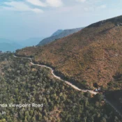
Galikonda View Point: Catching the Clouds at 4320 Feet
Tags