Where is Araku Valley Located? Maps and Geography for Tourists
Where is Araku Valley Located? Maps and Geography for Tourists
Understanding where Araku Valley is located helps travelers plan journeys, set expectations, and appreciate the geography that shapes this destination. Basic orientation information that locals take for granted often eludes first-time visitors researching trip options.
The geographic context explains why Araku offers cool temperatures, why reaching it involves winding roads, and how the valley relates to other destinations travelers might consider combining with their visit.
Geography: The Heart of the Eastern Ghats
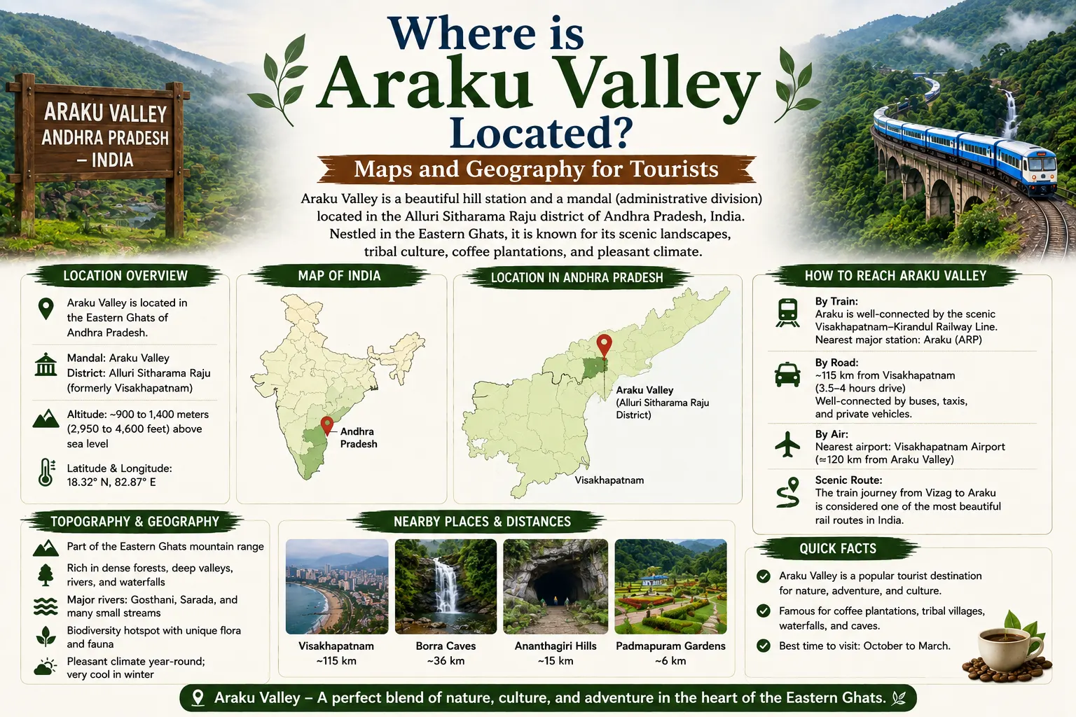
Araku Valley occupies an elevated plateau within the Eastern Ghats mountain range. The Eastern Ghats run roughly parallel to India’s eastern coast, forming a discontinuous series of hill ranges that extend from Odisha through Andhra Pradesh and into Tamil Nadu.
The elevation of the Araku Valley floor sits approximately 900 meters (roughly 3,000 feet) above sea level. This altitude creates the temperature differential that makes Araku notably cooler than the coastal plains below. To witness these highlands at their visual peak, it helps to check the best time to visit Araku Valley or review the specific Araku Valley weather in December trends before packing. The surrounding hills rise higher still, with peaks like Galikonda reaching over 1,100 to 1,300 meters.
The valley itself represents a relatively flat area surrounded by higher terrain. This geographic configuration creates a bowl effect that influences local weather patterns, including the fog accumulation that makes Araku famous during winter months. Cold air settling into the valley contributes to the temperature drops that visitors experience.
The Gosthani River system drains the valley, eventually reaching the Bay of Bengal. This river carved the famous Borra Caves over geological time and powers the waterfalls scattered throughout the region. The water patterns shaped the landscape visitors now appreciate.
Forest cover throughout the surrounding hills ranges from dense reserves to coffee plantations that replaced original vegetation. The biodiversity remains significant despite agricultural conversion, with endemic species inhabiting the less disturbed areas.
Which District is Araku in? (Alluri Sitaram Raju District)
Administrative geography affects practical matters including government services, emergency contacts, and understanding regional organization.
Araku Valley falls within Alluri Sitharama Raju District, an administrative unit carved from the larger Visakhapatnam District in 2022. The district naming honors a famous freedom fighter from this tribal region who led resistance against British colonial rule.
The district headquarters sits at Paderu, not Araku, reflecting administrative considerations beyond tourism importance. Travelers needing district-level government services would find offices in Paderu rather than Araku town.
The creation of the district acknowledged the distinctive character of this hilly tribal region compared to the coastal portions of the former combined Visakhapatnam District. The administrative separation allows governance better suited to the specific needs of this geography and population.
For most tourists, the district designation matters little to daily experience. However, understanding the administrative context helps when reading news, seeking information, or navigating any official requirements during travel.
The state of Andhra Pradesh contains Alluri Sitharama Raju District and thereby Araku Valley. Visitors from other Indian states need no special permissions to visit, and no international border complications affect foreign tourists traveling here from other parts of India.
Distance Chart from Major Hubs (Vizag, Hyderabad)
Understanding distances from major cities helps travelers plan journeys and estimate travel times.
From Visakhapatnam (Vizag), Araku Valley lies approximately 111 to 115 kilometers by road. The train journey covers a similar distance along a different route that includes the famous tunnels. Travel time runs approximately three to three and a half hours by road or four hours by train. Navigating these steep ghat curves safely is key, so reading through our Vizag to Araku by car guide before hitting the highway is highly recommended.
From Hyderabad, the distance to Araku Valley spans approximately 680–700 kilometers depending on exact routing. This substantial distance requires either overnight train travel, long road journeys with breaks, or flight connections to Vizag followed by surface transport.
From Bhubaneswar, the Odisha capital to the north, Araku lies approximately 500 kilometers. This distance makes Araku more naturally accessible from Vizag than from northern directions.
From Chennai to the south, the distance exceeds 800 kilometers, again positioning Vizag as the natural gateway rather than approaching from southern directions.
Within the Araku region, key distances include:
- Araku town to Borra Caves: approximately 30 kilometers
- Araku town to Chaparai Waterfalls: approximately 15 to 25 kilometers
- Araku town to Galikonda View Point: approximately 15 kilometers
- Araku town to Ananthagiri: approximately 25 kilometers
These internal distances affect itinerary planning since visiting multiple attractions in a single day requires sufficient transport time allocation. Easy transport options are available via automated Araku cab booking channels, and you can map out expenses using the Vizag to Araku cab fare log.
Spatial Relationships: Top 5 Sights in the Valley
Understanding the spatial relationships between major attractions helps visitors plan efficient routes.
Borra Caves sits northeast of Araku town along the road toward Visakhapatnam. Visitors arriving by road from Vizag pass near the caves before reaching Araku, allowing a stop on the inbound journey. To explore these subterranean chambers effortlessly, you can keep our up-to-date Borra caves guide handy. Train passengers continuing past Borra Guhalu station to Araku must arrange return transport to visit the caves. If you managed to secure seats on the scenic railway coach, keep our glass train Araku Vistadome guide handy.
The Tribal Museum and Coffee Museum cluster near Araku town center, within walking distance of each other and the railway station. Cultural walks are seamless via our Araku Tribal Museum guide. These attractions require minimal transport once you’ve reached the town area. If you decide to base your vacation in the central town plateau, you can scan options via our Araku valley hotels index or handle an instant online Araku valley rooms booking.
Padmapuram Botanical Gardens lies approximately three kilometers from Araku town center, a short drive or ambitious walk. Review our complete Padmapuram gardens Araku breakdown to perfectly coordinate your walk. The location between town and some outlying attractions allows efficient sequencing.
Galikonda View Point sits northeast of Araku town, requiring a dedicated trip up winding roads to reach the elevated vantage point. The spectacular Galikonda view point route offers unmatched panoramic views over receding mountain ridges.
Chaparai Waterfalls requires travel southwest from Araku toward Dumbriguda. This direction differs from other major attractions, meaning efficient planning groups attractions by directional cluster. The Chaparai waterfalls picnic guide showcases excellent natural rocky waterslides.
The geographic distribution of attractions means visitors benefit from organizing daily itineraries by direction. Morning north toward Borra Caves, afternoon back through town to museums, next day south toward waterfalls and west toward Ananthagiri creates efficient routing that minimizes backtracking. For secluded high-altitude getaways near the coffee fields, explore a tranquil Ananthagiri hills resort booking setup or choose from low-cost choices on our low price hotels in Araku valley portal.
Understanding where Araku Valley is located, from national geography down to internal attraction distribution, transforms abstract destination interest into concrete trip planning. For an entirely hands-off vacation where your stays, transport, and routes are bundled seamlessly, select a flagship Vizag to Araku tour package, an Araku Valley 1-day tour package, or look into the options on our main Araku valley tour travel packages portal.
Where is Araku Valley located exactly?
Araku Valley is a hill station located in the Alluri Sitharama Raju district of Andhra Pradesh, India. It occupies an elevated valley plateau in the Eastern Ghats mountain range close to the Odisha state border.
What is the distance from Visakhapatnam to Araku Valley?
The distance from Visakhapatnam to Araku Valley is approximately 111 to 115 kilometers by road. Travel time is roughly 3 to 3.5 hours by car or around 4 hours via the scenic passenger train route.
Which district administration handles Araku Valley?
Araku Valley is under the administration of the Alluri Sitharama Raju District, which was formed in 2022. The district’s official administrative headquarters is situated in Paderu town.
What is the elevation of Araku Valley above sea level?
The average altitude of the Araku Valley floor is about 900 meters (2,990 feet) above sea level, with surrounding mountain peaks climbing well past 1,200 meters.
Can I visit Borra Caves on the way to Araku town?
Yes, Borra Caves is located about 30 kilometers before reaching Araku town when traveling from Visakhapatnam. Stopping at the caverns during your inbound journey is highly recommended to maximize routing efficiency.
All Categories
- Araku Cab Service
- Araku Coffee
- Araku Tour Packages
- Araku Tourist Places
- Araku Trip Packages
- Araku Valley for families
- Araku Valley shopping
- Araku Valley Timings
- Araku Valley Trip Cost
- Araku Weather
- Camping in Araku Valley
- Hidden Spots
- Hotel & Rooms
- Hotels & Resorts
- Stay & Food
- Tatipudi Reservoir
- Tent camping
- Transport & Safety
- Travel Guides
- Vizag Attractions
- Vizag Beachs
- Vizag Cab Services
- Vizag Travel Planning
Recent Posts

Vizag Family Tour

TU-142 Aircraft Museum Guide

Vizag One Day Tour
Tags